Dear Customers,
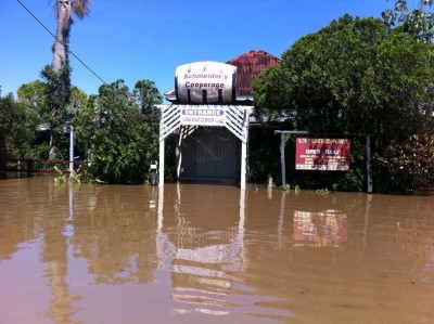
Due to the recent floods, our business has suffered some damage. We ask that if you have placed an order or know someone who has, to please be patient as we are set to reopen the shop on the 1/3/2013.
On Saturday the 26th of January 2013, ex-Tropical Cyclone Oswald crossed the Burnett River catchment causing a series of natural disasters to occur in the vicinity of Bundaberg, Queensland. A total of five (5) tornadoes struck the coastal fringe to the east of the city causing damage to the adjacent townships of Bargara and Burnett Heads. On Sunday the 27th of January, following significant rainfall across the catchment - the Burnett River broke its banks and the city of Bundaberg began to experience its largest flood in recorded history.
The events of January 2013 were preceded by moderate levels of flooding in the city of Bundaberg during December 2010 and January 2011. As a result of these events, Bundaberg Regional Council (BRC) undertook a review of its Local Disaster Management Plan and importantly commissioned a comprehensive flood study of the lower Burnett River. This included the development of a calibrated flood model. The timing of this study was fortuitous as the outputs of the model were used to inform emergency management decisions during the 2013 event. This highlighted the need for the floodplain risk management process to be underpinned by good science and sound engineering.
